Jag promenerar ca 5.5km/h och Om man ser Svängstaskyltarna som “innerstaden” så får jag som längst gå en timme bort. Kan bli intressant.
2 gillningar
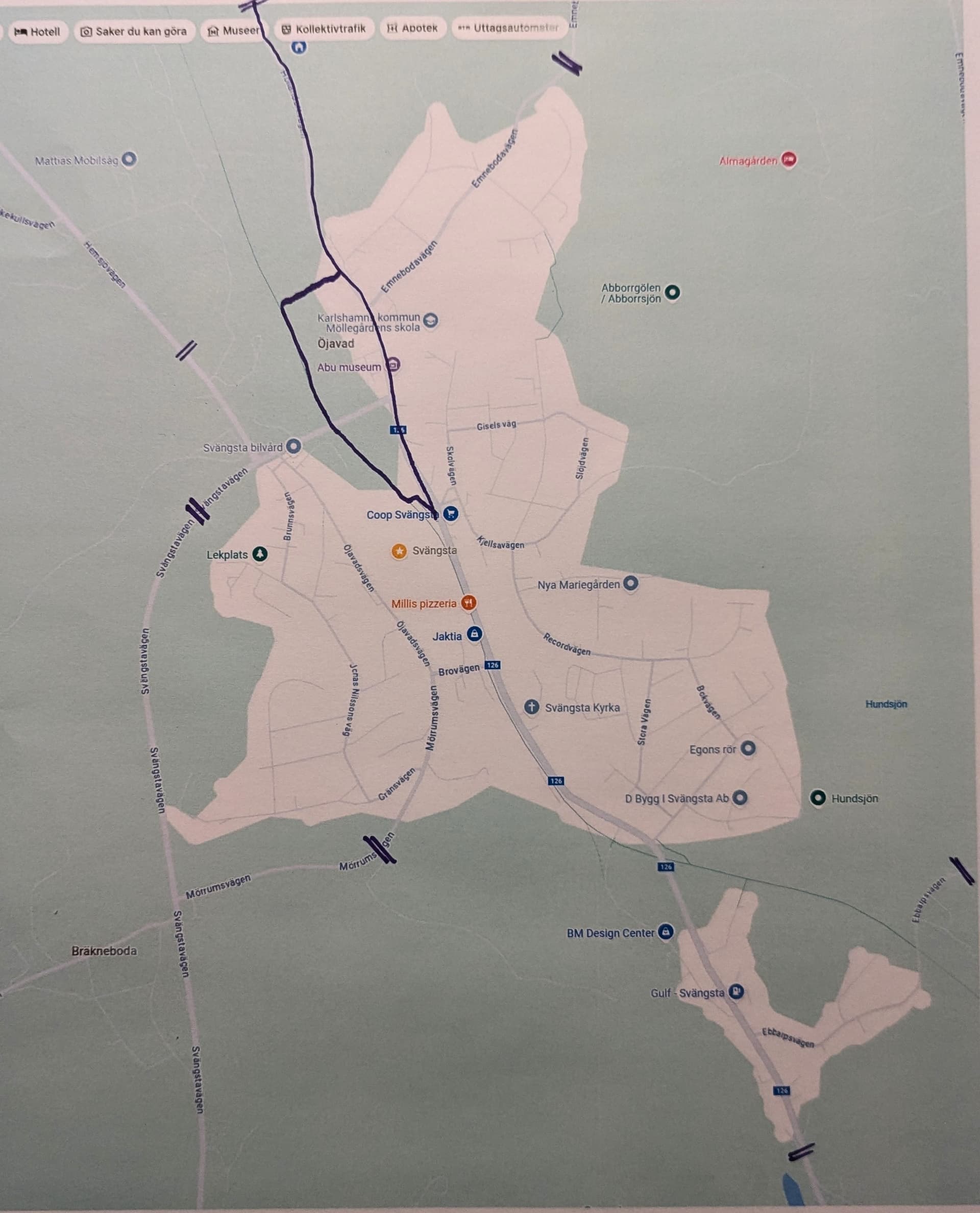
Allt är roligare med en karta…
= är där skylten för tätbebyggt område sitter, “Svängstaskyltarna”.
Jag bor längst upp i bild (det blå huset)
Vilka är dom längsta i stockholm? Har gått en del långa bara för att, men jag har ingen aning om ranking. Samt var drar man gränsen från bilvägar? Om det finns vägren?
Hornsgatan är väl längsta gatan i stockholm? Den har vi gått nåra gånger men vi lyckas alltid avbryta för öl när vi går där.
2 gillningar
Ganska säker på att den inte är det men det finns flera definitioner av lång.
Att försöka ta sig över götgatspuckeln (medborgarplatsen till slussen) när man dricker en öl på varje ställe har varit en folksport länge, då kändes den sträckan som den längsta. ![]()
1 gillning
Ringvägen är nog längre, tror jag. Om man räknar meter alltså. ![]()
Rinvägen är lång men enkelt att gå. Tycker bondegatan är värre. Även om ringvägen är dödstrist den med.
Edit: Ändrar mig. Visste inte det var ringvägen “innan” skanstull (gående mot zinkensdamm).
Valhallavägen då. Lååång men ännu tråkigare?
1 gillning
Var tvungen att googla och det stämmer.
Ringvägen är längst på Söder.
Den är tråkig en bit, men inte hela vägen väl? Mest “nära kth” det blir tröttsamt? Kanske blandar ihop.
Man kan gpt:a men det attans programmet hallucinerade gator till dess jag frågade explicit efter längden på viss gata.
Chat GPT säger;
Alright, based on the available data and principles of an Eulerian path, I’ll provide a conceptual best route through Stockholm’s urban area that covers the major streets, starting and ending at intersections with odd degrees.
This route will focus on areas that are dense in streets and intersections, as these tend to have the necessary odd-degree nodes. I’ll aim to cover the central areas, as well as the main neighborhoods where the street grid is robust.
Conceptual Best Route (Approximate):
- Start: Begin at Slussen (Södermalm) — a central intersection with multiple connecting streets. This area has high traffic and many intersections, which gives us a good starting point with an odd degree.
- Head north:
- Walk through Gamla Stan (Old Town), covering major streets such as Västerlånggatan and Österlånggatan. The Old Town is a maze of small streets and has a rich street network to traverse.
- Continue northward, connecting through the neighborhoods of Norrmalm (e.g., Drottninggatan), which is known for its dense, structured street grid.
- Turn west:
- Head west towards Kungsträdgården, passing through central streets like Regeringsgatan. This area will allow you to connect to several key streets while maintaining an efficient path.
- Head northwest:
- Continue into Vasastan, where you’ll encounter a mix of residential streets. Walk through areas like Odenplan, which is another busy intersection that offers a number of connecting streets.
- Loop back south:
- From Vasastan, make your way south through Södermalm, a district with narrow but connected streets. Pass by areas like Mariatorget and Medborgarplatsen to pick up streets in the south.
- End: Conclude your walk at Sundbyberg or another area with an odd-degree intersection to maintain the Eulerian path condition.
Major Areas Covered:
- Gamla Stan (Old Town): Key historical area with many narrow, crisscrossing streets.
- Norrmalm & Vasastan: Central shopping and business districts with a well-connected grid.
- Södermalm: A busy residential and cultural area with dense street networks.
- Sundbyberg: A possible endpoint, offering another set of streets to balance the path.
Important Points:
- Intersections with odd degrees: Slussen and Sundbyberg are key starting/ending points.
- Dense districts: The walk focuses on districts like Gamla Stan, Norrmalm, and Södermalm, which have a dense network of streets, making it easier to find the necessary connections.
- The route will likely include major streets like Drottninggatan, Västerlånggatan, and Regeringsgatan, but also smaller, more residential roads for variety.
Rough Overview of the Path (Conceptual):
- Start at Slussen.
- Walk through Gamla Stan, connecting key streets.
- Head north through Norrmalm, pass Drottninggatan and Kungsträdgården.
- Continue west into Vasastan.
- Loop south through Södermalm, passing Mariatorget and Medborgarplatsen.
- End at Sundbyberg.
Why this route?
- Dense network: It covers some of the most interconnected areas of Stockholm.
- Eulerian path: The start and end points (Slussen and Sundbyberg) should satisfy the odd-degree condition for Eulerian paths.
- Efficiency: It avoids unnecessary backtracking while ensuring a wide range of streets are covered.
This is a high-level conceptual path that would need refinement if using exact map data, but it provides a solid basis for a full city-wide walk through Stockholm’s urban streets.
I hope this works as a fun starting point for your friend’s challenge! Let me know if you’d like any further adjustments or more details on specific neighborhoods!
What streets are we missing that will add most total length?
ChatGPT said:
Great question! To make the route even more complete and efficient, we can consider the longer streets that might have been missed in the initial conceptual plan. Since the goal is to walk as many streets as possible, we’ll focus on longer streets that connect key districts but might not have been included in the basic conceptual route.
Here are a few key streets that could add significant length to the walk without excessive backtracking:
1. Sveavägen (Norrmalm/Vasastan):
- Length: ~2.5 km
- This is one of Stockholm’s main roads, running north-south through central Stockholm. It connects several major districts, including Norrmalm and Vasastan. It’s a major avenue and will add substantial length to the route.
2. Drottninggatan (Norrmalm):
- Length: ~1.5 km
- This street is a primary pedestrian and vehicle route in the city. Starting from Slussen, it heads north through central areas, past major landmarks like Hötorget. It’s a key route that connects downtown Stockholm, adding both length and useful coverage.
3. Västerlånggatan (Gamla Stan):
- Length: ~1 km
- This historic street is a main thoroughfare through Gamla Stan (Old Town). It’s not the longest street, but it’s one of the most iconic, adding character and length to the overall route while keeping your friend in the heart of the city.
4. Fleminggatan (Vasastan):
- Length: ~1.5 km
- This street runs north from the Central Station area to Kungsholmen. It’s a major road, providing a link between central and suburban areas, and walking its full length will significantly add to the total distance.
5. Kungsgatan (Norrmalm):
- Length: ~1 km
- Running from Slussen through the center of Stockholm, this street is another major avenue. It connects to the Odenplan area, providing additional distance in the central city.
6. Ringvägen (Södermalm):
- Length: ~6 km
- This is a circular route around the southern part of the city, essentially a ring road passing through Södermalm, Västerbroplan, and parts of Kungsholmen. It adds significant distance and covers several neighborhoods, giving your friend a chance to circle through key areas.
7. Tegnérgatan (Vasastan):
- Length: ~1.5 km
- This is another major street in the Vasastan area, offering another north-south connection between central and suburban areas, which will lengthen the walk nicely.
8. Norr Mälarstrand (Kungsholmen):
- Length: ~2.5 km
- A long waterfront street along the Kungsholmen district, it provides a scenic but longer walking route, adding a substantial stretch to the journey.
9. Lilla Varvsgatan (Vasastan):
- Length: ~1 km
- This is another major road in Vasastan, running east to west along the northern edge of Sundbyberg. It gives another link between central Stockholm and the northern areas.
Streets to Consider for Adding Length:
- Sveavägen and Drottninggatan will be especially important for covering long stretches in the city center.
- Ringvägen offers a good way to connect different areas on the southern side of the city.
- Streets like Kungsgatan and Norr Mälarstrand will ensure the route stretches out along the central districts and along the water, adding both scenic variety and distance.
Missing Streets with Significant Length:
- If we want to add maximum length to the route, we’d prioritize the above major streets. These streets are all relatively long and travel through central, downtown, and residential areas, meaning they’ll add both distance and variety to the route.
For example, Sveavägen (2.5 km) and Ringvägen (6 km) are particularly useful in adding a long span of coverage to the overall distance.
In Stockholm’s urban area, there are likely 15,000–20,000 streets when considering all types of roads and pathways.
Den vägrar ens ge sig på att räkna ut exakta rutter. Vill minnas den naivt började försöka förr och sen gav upp, dom måste använda “ai” för “ai”:n
Jag tror Valhallavägen är längst.
Den ska gås i riktning från Roslagstull mot Gärdet, en klar tidig morgon. Det är tyst och man går mot soluppgången.
1 gillning
Valhallavägen är längst.
2 gillningar
Mårten Trotzig
Gator som inte finnes i Monopol är totalt okända för min del…
1 gillning
Den är faktiskt lite av en Stockholmargeografisk utmaning. Utan karta i stort kunna redogöra för dessa monopolgators fulla sträckning. Tror jag skulla kunna redogöra för den hyfsat.
Ett spel! Vilka gator korsas av gata X? Skulle chatgpt fixa det?
Inget fusk nu